Description


An epic sea kayaking adventure down the west coast of Canada.

Wednesday, June 29, 2011

Anger Island (Pitts Island)

Today's check-in appears to be from Anger Island, not far from Sine, Cosine, and Tangent Islands, which are all very close to Pitts Island.

Today's distance traveled is at least 20 nautical miles. Updated kmz.

Based on its reported location, this image appears to be looking across the Principe Channel toward their current camp.

This is the closest they have come to Jonathan's 2006 expedition. They are within 4km of his camp of 22 June 2006. My record of kmz files from that trip is here.

They are not far from the Bonilla Island remote weather station. It's current report is copied below. It appears that in the open waters winds were steady today around 10 knots, shifting from WSW in the morning to SSW in the afternoon.

Bonilla Island

06:00 PM PDT 29 June 2011
Wind (knots) SSW 10 Air temperature (°C) 13
Conditions N/A Relative humidity (%) 81
Visibility (km) N/A Dew point temperature (°C) 9
Pressure and tendency (kPa) 100.4 Humidex / Wind Chill --
Sunrise 5:16 PDT Sunset 22:15 PDT

Check-in/OK message from The Pilgrims SPOT Messenger

The Pilgrims
Latitude:53.52663
Longitude:-129.98103
GPS location Date/Time:06/29/2011 14:51:28 PDT

Message:Hello everyone! Just checking in to let you know where we are and to say all is well! J, K and J.

Click the link below to see where I am located.
http://fms.ws/5DO1q/53.52663N/129.98103W

If the above link does not work, try this link:
http://maps.google.com/maps?f=q&hl=en&geocode=&q=53.52663,-129.98103&ll=53.52663,-129.98103&ie=UTF8&z=12&om=1

The Pilgrims

You have received this message because The Pilgrims has added you to their SPOT contact list.

Every day is an Adventure. Share Yours.
http://www.findmespot.com

Tuesday, June 28, 2011

McCauley Island

Today's check-in is from McCauley Island. Google Earth suggests they have some interesting little islands with significant topography. They are looking out onto a vast amount of open water. Based on reported and forecast weather conditions, they seem to be experiencing damp, cloudy weather. As of 4pm the Marine forecast is reporting NW winds of 10 to 20 and seas of 1 metre.

They appear to have covered at least 24 Nautical miles today. Yesterday was at least 18. Day 1 was at least 7.

If anyone has any pictures of this area please post links as comments.

I have updated the kmz file with all points so far.

Check-in/OK message from The Pilgrims SPOT Messenger

The Pilgrims
Latitude:53.69583
Longitude:-130.39513
GPS location Date/Time:06/28/2011 17:33:55 PDT

Message:Hello everyone! Just checking in to let you know where we are and to say all is well! J, K and J.

Click the link below to see where I am located.
http://fms.ws/5Cqkf/53.69583N/130.39513W

If the above link does not work, try this link:
http://maps.google.com/maps?f=q&hl=en&geocode=&q=53.69583,-130.39513&ll=53.69583,-130.39513&ie=UTF8&z=12&om=1

The Pilgrims

You have received this message because The Pilgrims has added you to their SPOT contact list.

Every day is an Adventure. Share Yours.
http://www.findmespot.com

Monday, June 27, 2011

SPOT Check-in from Oval Bay

Latest SPOT check-in is from Oval Bay on Porcher Island.

Updated kmz file.

Looks like they started earlier than my last post suggested.

Check-in/OK message from The Pilgrims SPOT Messenger

The Pilgrims
Latitude:53.99143
Longitude:-130.66536
GPS location Date/Time:06/27/2011 12:13:33 PDT

Message:Hello everyone! Just checking in to let you know where we are and to say all is well! J, K and J.

Click the link below to see where I am located.
http://fms.ws/5C0pf/53.99143N/130.66536W

If the above link does not work, try this link:
http://maps.google.com/maps?f=q&hl=en&geocode=&q=53.99143,-130.66536&ll=53.99143,-130.66536&ie=UTF8&z=12&om=1

The Pilgrims

You have received this message because The Pilgrims has added you to their SPOT contact list.

Every day is an Adventure. Share Yours.
http://www.findmespot.com

Sunday, June 26, 2011

Phone Update from Kitson Island [Updated!]

Kirti called in on her cell phone. This is probably the only time this trip they will have cell phone coverage.

Ferry Ride: They enjoyed the ferry ride to Port Hardy. On the way they saw "loads" of porpoises surfing the wake left by the ferry. They also saw humpback whales. It was a very good crossing.

Port Hardy: They camped right at the marine dock.

Today: They were underway at first light this morning, about 3:30am. They arrived at Kitson Island at about 6:30am. After arriving they had a nice breakfast, checked in on the SPOT, and then took a nap until about noon. They have a very nice camp.

Update: Today's Eagle count is 52! Many of them on Kitson Island.

Tomorrow: They plan to head to Porcher Island. The tentative plan is to camp at Oval Bay, on the Northwest coast. Update: They will be getting a late start, paddling on the ebb tide that begins around noon.

Overall Assessment: "Good so far!"

Kitson Island Marine Provincial Park

The first two check-ins show the Pilgrims have traveled from Prince Rupert to Kitson Island Marine Provincial Park. Google earth records two beautiful images of a nice sandy beach taken near their location (first image) (second image). They appear to have had a nice early start, getting off the water by 8:21 this morning.

Google earth kmz of their progress.

Check-in/OK message from The Pilgrims SPOT Messenger

The Pilgrims
Latitude:54.17839
Longitude:-130.31355
GPS location Date/Time:06/26/2011 08:21:40 PDT

Message:Hello everyone! Just checking in to let you know where we are and to say all is well! J, K and J.

Click the link below to see where I am located.
http://fms.ws/5BD1Z/54.17839N/130.31355W

If the above link does not work, try this link:
http://maps.google.com/maps?f=q&hl=en&geocode=&q=54.17839,-130.31355&ll=54.17839,-130.31355&ie=UTF8&z=12&om=1

The Pilgrims

You have received this message because The Pilgrims has added you to their SPOT contact list.

Every day is an Adventure. Share Yours.
http://www.findmespot.com

Saturday, June 25, 2011

Check-in/OK message from The Pilgrims SPOT Messenger

The Pilgrims
Latitude:54.29573
Longitude:-130.35162
GPS location Date/Time:06/25/2011 23:13:32 PDT

Message:Hello everyone! Just checking in to let you know where we are and to say all is well! J, K and J.

Click the link below to see where I am located.
http://fms.ws/5A_SD/54.29573N/130.35162W

If the above link does not work, try this link:
http://maps.google.com/maps?f=q&hl=en&geocode=&q=54.29573,-130.35162&ll=54.29573,-130.35162&ie=UTF8&z=12&om=1

The Pilgrims

You have received this message because The Pilgrims has added you to their SPOT contact list.

Every day is an Adventure. Share Yours.
http://www.findmespot.com

Friday, June 24, 2011

The last supper

On arriving in Port Hardy we bumped into a group of old friends: Diane and Les Uhrich, Rhonda Schwab, Chris Smith, Julie Beck, David Price, Dave Agnew, and Roxie Dufour. They had just completed a sea kayaking trip of their own out to the Brooks Peninsular and back. They were regrouping and sorting out their stuff before heading back to Washington. They invited us over for dinner and we enojoyed a nice evening sharing strories and listening to Les tell jokes. Hopefully, Rhonda will email a picture to Jim when she gets back home so he can post it to the blog. We're off to bed now so we can be up at 5am to catch the ferry up to Prince Rupert. If all goes well we'll arrive there late tomorrow night and be on the water by Sunday morning. This will be the last direct post for quite some time. Kirti is hoping that wasn't really our last supper.

Thursday, June 23, 2011

Ah! Canada!

After a smooth drive and quick border crossing we are now in Tsawwassen, British Columbia. We're staynig here for the night and will be catching the ferry to Nanaimo on Vancouver Island tomorrow morning. From there we'll drive up to Port Hardy where we'll be staying with Pat Kervin at Odyssey Kayak and Dive Center. Ah, Canada! Its starting to feel like a vacation already!

Wednesday, June 22, 2011

Packing

We're leaving tomorrow morning, so today was spent packing. This not only means making sure everything we need for the trip will fit in our kayaks easily and efficiently, but also making sure that everything will fit in the car for the drive up there. Here is a glimpse at what we're taking on the first leg of the voyage - food and everything else we need for almost a month. We also have a big pile for the second leg! Packing the car is going to be interesting.

The Pilgrims and their cargo
Jenny and Kirti with their kit
Jonathan's Explorer and its precious cargo
Jonathan and Kirti with the kayaks and gear ready to haul

Tuesday, June 21, 2011

Preparing for the Voyage

Its been a busy few days trying to get finished up with work and fully prepared for the trip. Aside from wrestling with the blog site, we've been rounding up all our equipment and test packing the kayaks. This has involved planning, buying, sub-dividing and packaging up food for 25 days, sufficient to sustain us until our first resupply in Port Hardy. We've also been buying and preparing what we can for after the resupply.

All our food is stored in zip lock bags, which in turn are in odor-proof bags, then in dry bags, and finally in kevlar bear bags. These slip right into our kayaks' storage compartments so we don't have to unpack and pack the food every day. At least, we don't have to take it in and out of these bags. Of course, the full bags will be taken out of the kayaks each night and hung, to make them a little harder to find (by bears) and to make it less likely that our kayaks get destroyed. We're hoping that with these precautions, coupled with careful planning about where, when and how we eat and camp, we'll be the ones actually eating all this food we're hauling down the coast of "The Great Bear Rainforest".  Making a compact bear bag hanging system that could handle this much weight was also a bit of a project, but we have that all done now too.

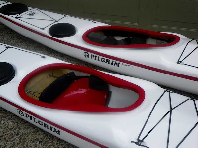
We've also had to manufacture and test three inexpensive kayak trolleys for getting our kayaks on and off the Inside Passage ferry, and to the water. Our neighbors have commented how "normal people walk their dogs around the neighborhood. You guys walk your kayaks!". At least we know the trolleys work, and I think the neighbors are used to our strange behavior by now. We plan to leave the trolleys at Prince Rupert because we will not have the capacity (or desire) to haul them on our journey, and we won't need them after the launch. Hopefully, other kayakers will get some good use out of them up there!

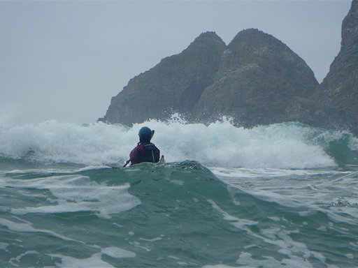
Jenny training for the voyage at the Oregon Coast
We've been training for the trip out on the Oregon Coast and on the Columbia River. After a few sessions of getting pummeled in the surf the past two weekends, our last two test runs this weekend were on the Columbia River. Sunday was a nice easy 15 mile cruise down river in calm conditions, but Saturday's trip in the Gorge was a true rough water test. We had gusty winds to 30 knots opposing a record river discharge, which made for some challenging "tide race" type conditions. We were able to find the limits of our strength and paddling skills, which always makes for a humbling experience. I think this kind of experience is good before a big trip because it reminds you not to let your guard down. The wind and sea can easily render you helpless if you make a bad decision. Don't wrestle Neptune!

The past few days preparing have been hard for me (Jon) because my father died on Friday. I've been struggling to reconcile some issues which has made it difficult to concentrate fully on the preparations for our trip. I took time out on Friday to go for a long bike ride, because he and I had many happy times cycling together, and I played a tune (Sgaruint Na Gcompanagh -- The Parting of Friends) on my flute to help him on his journey. Now I need to prepare for mine.

Saturday, June 18, 2011

A sneak preview

Here's is a sneak preview using some pictures from our previous trips down the Outside Passage and around Vancouver Island.

Wednesday, June 15, 2011

Overview

Section 1 - Hecate Straight
Section 2 - Queen Charlotte Sound
Section 3 - Vancouver Island
The Voyagers

The Pilgrims


In case you were wondering who the Pilgrims are, the paddlers are Jonathan Walpole, Kirti Walpole and Jenny Johnson, but the Pilgrims are Kirti's and Jenny's new kayaks (Mayflower and Speedwell). They are "Pilgrim Expedition" sea kayaks from Sea Kayaking UK (SKUK), designed by Nigel Dennis specifically for smaller paddlers. This is their first major expedition and we are keen to see how they fare. Hopefully, the Speedwell will fare better than the original!

Like the early pilgrims we'll be embarking on a sea journey in search of freedom, and we'll be heading for America, but unless our navigation goes horribly wrong we won't be crossing the Atlantic! Instead we'll be paddling a combination Outside / Inside Passage route from Prince Rupert at the northern end of Canada's west coast to Victoria at the southern end. Our exact route is not fixed. This is not about conquering anything or breaking any records: we plan to move cautiously and let nature determine our pace and route.

We hope to send position updates via SPOT most days so people can follow our progress. Less frequently we'll try to communicate via satellite phone to a friend so he can add the occasional update to this blog. However, please note that we will be in very remote wilderness areas for the vast majority of our journey, so it may prove difficult to make contact for extended periods of time. Please consider absence of contact to be normal and any updates that appear to be the exception!

Our Schedule


June 23 - Drive from Portland, Oregon to Vancouver, British Columbia

June 24 - Ferry to Vancouver Island, drive to Port Hardy
(stay with Pat Kervin of Odyssey Kayaking & Dive Center)

June 25 - Inside Passage Ferry to Prince Rupert

June 26 - Launch